Thursday, December 13, 2012

Connecticut in the Dark

I spent this week working in my company's office in Glastonbury, CT. On the evening of my last day I had the opportunity to ride some trails in a local park -- in the dark. The husband of one of my coworkers, we'll call him Evan (since that's his name), is an avid mountain biker and former cross country mtb racer; I've heard many tales of his cycling adventures, mostly related to broken bones and broken bike frames. When I started planning my trip, he suggested we get together for a ride. Although I was skeptical that it would actually work out, and a little concerned about what I might be getting into, I packed my bike shoes and some cool weather clothes, a set of pedals, and my helmet. I'm glad I did.

We rode at Day Pond State Park.

The park was an interesting mix: forest, ferns, logs, and leaves that reminded me of the trails we used to ride in Michigan, but with slanted slabs and slippery rocks and deathly dark and dangerous drops more like one might find in Grand Junction's Lunch Loops or some of the more technical trails in the Buffalo Creek Recreation Area much closer to what is now home. I would like to see this park sometime when the sun is up! At night, in the beam of a bright headlamp, the granite on the trail sparkled like stars in the sky.
I was afraid I was in trouble when my riding companions unloaded their burly all-mountain bikes with big travel and big brakes and then donned their hard plastic body armor. I felt naked and unprotected! Nonetheless, I pedaled off with them into the dark on a borrowed bike that didn't fit, on a trail strewn with in frost-covered leaves.

The trail was challenging. I did not feel that my riding was up to my normal level, largely because I was not on my familiar steed; I was riding a borrowed Gary Fisher Cake that used to be Evan's. It was nicely upgraded with a five-inch Fox Float fork and very effective hydraulic disc brakes, but it was really too small for me. I could not find a comfortable balance point; the fork, shock, and tires all had more air pressure than they should have for my skinny butt. I was perpetually struggling with traction and balance, and found the bike's handling very twitchy with overly sensitive steering. I was scared of the log skinnies, and stayed away from many of the big jumps. The rock gardens gave me fits! Oh, for my Nickel!! But it was still great fun, and so much better than just sitting back in my hotel room at night working!

At one of the first of the more challenging obstacles on the trail, Evan easily rode down a steep granite 'roller' -- a name he used for very steep drops that had just enough angle that they could be ridden rather than jumped. I was not comfortable trying to roll down it on the undersized bike so I wheelied and attempted to gently jump off the three-foot high rock; it worked, sort of, except that when I finally reached the ground, I landed on my back tire, and was then unable to bring the front end down, I rode it out for a few feet, but eventually rolled over backward and landed hard on my back. That left a mark. Consequently, I came away from the ride with a few minor bruises, but Evan later had a big rock-slide crash that definitely won the best-crash-of-ride award. At first I thought he might have been seriously injured, but eventually his wind returned and he stopped making horrific sounds.

This was my first time riding trails at night. I used Evan's new NiteRider MiNewt 750 mounted to my helmet. The light was great; I rarely had any issues with visibility, as the light created a perfect patch of daylight on the trail in front of me. However, my lack of familiarity with the trails and the poorly fitting bike slowed me down significantly. I will have to go back!  Only next time perhaps I'll bring my Nickel...

Sunday, November 25, 2012

Moab and the Rest of November

We've reached the end of the Thanksgiving weekend and I'd like to wrap it up with a short blog. I'm not quite sure how to cover everything that ought to be here: As indicated from the title of this post, in the chronology of the blog, I should be covering our first day in Moab with the Diddiwah, which was back on November 2nd. Since then, all sorts of blog-able stuff has happened, but I don't want to miss the chance to post some Moab pics. Yet, I also think it's unreasonable for me to attempt to post everything individually. So I'll just start working backwards and see where I end up.

This morning, we made a quick trip out to Alderfer Three Sisters Park to get in a ride before Cindy went to work at 3 p.m. We parked in our usual spot and started out on the usual route (click here for a previous post), we opted to include the Summit Trail in our usual loop, which added another 250 feet of climbing at the beginning of the ride; which means we climbed right at 1000 feet in 3 miles. Everyone, even Quinn, did an incredible job of climbing and navigating the tough spots. In the past, Quinn has struggled with the 750 climb, but he was much stronger today. Maybe it was because I offered him $5 if he could make it to the summit, the full 1000 feet without complaining.


Yesterday, we went to Roxborough State Park with the Diddiwah and Chris's uncle, Roger. It was a walking trip, not a peddling one, but it was very nice, despite the clouds and cool temperature, and lack of bicycles. Heather and Chris had planned to bring bikes when they came over to Denver for the weekend, but Heather's injuries, broken finger and internal bruising (you'll have to ask her), are keeping her off her bicycle for a few days. This time at Roxborough, we took the South Rim Trail, which presented us excellent views of the valley to the north.


Abbey, a wary eye and a sock monkey hat.


And the day before that was a trip to the zoo. And before that was Thanksgiving. It had been several years since we'd had a Thanksgiving dinner with any family other than the immediate. In Michigan, we usually had dinner with some of our neighbors and about thirty of their closest friends. This year we cooked dinner at our house and were joined by the Diddiwah and Bob and BJ. It was nice; we spent quite a long time sitting in our living room, playing music, and talking while we waited for the turkey to hit 165. I didn't get any pics of any of it.

And between Moab, on the 4th of November, and Thanksgiving Day? Well, Quinn's been playing basketball, Abbey made first chair in the Cherry Creek District Middle School Honor Band. I went to Long Beach, CA, for a week. Cindy's been holding it all together as usual. We've had some runs and some rides, but nothing I'd consider a reportable adventure. So with that, I think I'm ready to get back to posting Moab pics.

The morning of Friday, the 2nd of November, we awoke in Grand Junction and, after coffee and breakfast,  packed up to drive to Moab and find a campsite. And then we did. And then we went riding at the Bar M trails. The Bar M trails are short distance north of Moab, and comprise a network of trails that are mostly on pale slickrock called Entrada sandstone. We rode Lazy EZ, Bar M, Circle O, and Rocking A. It was too much fun!!

Our caravan heads off into the Utah desert with the Utah dog in the lead.


Below, Abbey follows the trail down a steep slab while Cindy waits here turn. On the slickrock, all of the trails are marked with paint, so that trail users will neither become lost forever in the desert nor find themselves riding off an unexpected cliff.


Chris and Cailan prepare for the descent:


Heather rides her new machine through one of many sharp dips between slabs, with Abbey and Cindy following:


We all enjoyed riding the slickrock at the Bar M trail area. It was moderately challenging in terms of technical riding, so it was quite fun.  It was flat, in terms of elevation, so it was not necessarily aerobically challenging. Of course, after something like 9 miles of continuous riding through terrain like that in the picture above, it was exhausting!

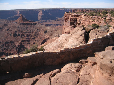
On our second day in the Moab area, we drove up out of the Colorado River valley to Dead Horse Point State Park. The park provides incredible views of the Colorado River, and has a recently built mountain bike trail system, the Intrepid Trail system, which makes really nice way to travel around the mesa and access the incredible scenery.

We thought we could get a nice family picture at the first overlook. It didn't work. And yes, that rock behind us is the edge of a thousand-foot cliff. Even Chris and Quinn stayed comfortably back from the edge.


The Intrepid Trail itself was located far from the cliffs, but there were bike racks and short foot paths at each of the overlooks.


Lunch after riding the Intrepid Trail.


The overlook at the picnic area. I was not especially comfortable at this one.


Not only was the scenery nice, but riding the Intrepid Trail was really fun. It's considered a kid-friendly trail that is accessible to all levels of riders, but it had enough interesting features, including rock ledges, short rocky climbs, and lots of curves, that it would be fun for just about anyone. Definitely worth another trip around the loop!

At the campsite on the morning of our last day:


After packing up our campsite, we drove north past the Bar M trails to the Klondike Bluffs area for another ride on pale slickrock. We followed the original Klondike Bluffs 4x4 trail up to the border of Arches National Park where there was a foot-only path into the park. It was worth the walk into the park.


On the Klondike Bluffs Trail we followed the footprints of dinosaurs; Cailan added water so we could see the toe prints.


Much of the trail was a flat, steep slab of sandstone...


...but not all of it.


A pin popped out of Abbey's chain and it took us a while straighten the links that bent when it happend, and then to push the pin back into place. I was glad I brought my chain tool, as it would have been a long walk out with out it!


Walking into Arches National Park:


A rest and a snack on top of a rounded column:


After our snack in the sunshine, we walked back to the bikes, and then rode back to the trail head down the rock slabs much faster than we'd come up. And that was the end of our trip. That night we were back at home, and back to work and school the next morning.  


Saturday, November 10, 2012

Trip to Grand Junction

The day after Halloween, we drove across the mountains to Grand Junction to meet up with the Diddawah  for a camping trip in Moab. We'd planned to leave early enough to do some riding when we got to GJ, and we did, but it was close. We didn't leave as early as we'd hoped because it's so difficult and always takes so long to pack all of our stuff into and onto our truck. Also, the closing on our Michigan home was occurring coincidentally, so during our drive to GJ we had to stop in at a FedEx store to print, sign, and fax a few more documents, which ate up a good couple of hours. It all worked out though: the closing went through on the Michigan house and we made it to Grand Junction in time to get in some riding.

We started at the Loma parking lot at the Kokopelli trails near Fruita and rode Rustler's Loop and part of Mary's.


Rustler's is an easy 3.5-mile loop trail that runs along the perimeter of a bench overlooking the Colorado River. The trail stays comfortably back from the edge in most places, but the views are incredible. We were a little concerned that our Mousie might not understand the concept of a cliff and would just run right off. For better or for worse, it appears that he has an instinctive understanding of this particular peril. He ran up to the edge several times, but always stopped just short of falling.


It was getting late in the day, so we didn't have as much time as might have been nice, but with the sun near the horizon, the scenery was wonderful.


After the ride, we went to the Diddiwah's house for some delicious home made pizzas. The next morning, we followed the Colorado River further downstream to Moab.

Wednesday, October 24, 2012

We are still here.

Just too busy to have time to keep up with the blog right now. We've had some great rides and I have some photos to post and stories to tell. I just don't have enough time to tell the stories.

Quinn is playing the trombone. He has band twice per week before school. We've signed him up to play on a basketball team this winter, too.
Abbey is playing the trumpet, and is playing in jazz band twice per week after school. She's also in a play, something about the Titanic, and has play rehearsals on the same afternoons she has jazz band. She needs a time turner to make this work.
Cindy is once again working in the retail running shoe industry. It seems like a good job, but there is only one Playmakers. And we're not clearing enough to stay on top of things right now.
I specialize in environmental insanity. I'm currently spending all my extra time working at home on some self-inflicted complex data analysis project.
We're getting ready to take a trip further west for a camping and mountain biking trip with the Diddawah in Moab.
We may be close to closing on the sale of our house in Michigan. That will be a huge relief.
We're definitely not as comfortable in this smaller, run-down rental house, but we're likely going to be renting for the next few years. Maybe we'll find a larger, nicer place, but we haven't seen anything we could afford.
We are getting our second snow of the season tonight. The first, a few weeks ago, we just a dusting. This one might hold more.
And occasionally, just a little bit, I really miss the comfortable life we had in Michigan.

Sunday, September 23, 2012

Centennial Cone Park

On September 22, 2012, we made the trip to Centennial Cone Park to ride the Travois Trail, which makes a 13-mile loop around the Centennial Cone.

On even-numbered weekend days, this trail is open only to mountain bikes, whereas on odd-numbered weekend days, it is open only to hikers (and presumably walkers and runners). Humans on horses may use it at anytime, and everyone must share during the week. This is an interesting arrangement; I'm curious about the events and negotiations that led to such rules. I suspect that the nature of the trail contributed: For several miles of its length, the Travois trail is very narrow and traverses frighteningly steep slopes, dropping hundreds of feet into valleys below. Trail user conflicts could conceivably result in long slides or even falls. Was this a factor?

I've figured out how to use my Android app, My Tracks, (again), and I also remembered my extended smartphone battery, so I was successful in logging our route.

Clear here to see our track using Google maps.

I really like being able to pull the raw data from My Tracks and work with it myself:


Did I mention that Centennial Cone Park is just ridiculously beautiful? Huge, expansive views of the surrounding mountains and valleys. My camera battery was dead so I borrowed Abbey's. Hers is not quite as nice as mine, so the pictures aren't as good as usual -- not that my camera is anything other than a cheap point-and-shoot digital, but it seems to have a nicer lens than Abbey's.   


That pointy thing with all the trees on it in the picture below is Centennial Cone. Part of the trail is double-track, also visible in the picture.


We saw this girl on a green bike on the trail. She was so cute we brought her home after the ride.


Most of the Travois Trail was smooth and non-technical; the ride was more of an aerobic and physical challenge than it was a technical one. However, there were plenty of tight switch-backs and even some rock steps to negotiate. Many of these were perched above steep drops, which added some intensity to the experience.


Don't overshoot this switch-back!


The girls.


We also ran across this surfer dude riding the back of a tandem. What a nut.


We found this to be one of the most stunningly scenic trails we've ever ridden. It's definitely on the list for trails to experience more than once! We also found it to be a surprisingly challenging 13-mile loop. I'm not sure if it was more challenging than expected due to the steepness of the many climbs or whether we've just gotten out of shape. Maybe the surfer dude was feeling lazy.

Monday, September 3, 2012

Camping

Over Labor Day Weekend, we made our first camping trip since moving to Colorado. We left home Saturday morning, our truck loaded with bicycles and camping gear, heading to a campground not too far from Leadville. Until we changed our plan, that is. We weren't far down the road when we decided to go back to the Fraser Valley instead. We made that last-minute decision because the Fraser Valley was familiar, it was reasonably close, and generally seemed like a safer bet than risking our only camping trip on a place less familiar.

There are plenty of trails and gravel roads in the Fraser Valley for hiking and cycling, and the trails are dog-friendly, so Amos could come along with us. Here's a map. Our hope was that we could mix things up with some rides done by all of us, and some with subsets. It sort of worked out that way.

We camped at the Saint Louis Campground just outside of Fraser, which is slightly north of Winter Park. There aren't many live trees left in the area since the pine beetles have killed so many of them. The Forest Service has removed the dead trees from the campground -- it would not be safe to have people camping in a forest of dead and falling trees. Perhaps that's partly why the campground was only about half full on Labor Day Weekend, although the camp host said they'd been full every weekend during the preceding month.

Upon arriving at the campground Saturday morning, we selected a campsite and set up the tents, and then had to fix flat tires on Quinn and Cindy's bikes from thorns picked up the previous day on a ride near our house. I lost count of all the thorns we found in Quinn's tires. Only his front needed to be fixed since the self-sealing tube in his rear tire did its job.

After the tire repairs and a quick lunch, the five of us ("scaqa," if you want to add Mousie to the acronym) headed up the Creekside Trail, which runs right through the campground. It is a very pleasant, somewhat rocky trail than meanders through the forest and meadows on the west side of Saint Louis Creek, going upstream towards the south for about two miles. We'd ridden it a few times over the summer already. This time, however, rather than coming back down the Flume Trail on the east side of the creek, we headed further out and up to catch Zoom and Chainsaw which loop around and meet up with Creekside (and Flume) a little downstream of the campground. It was great loop, although the climb up the gravel roads to Zoom was tough -- especially for Quinn. He made it, though, and he definitely enjoyed the subsequent ride down Zoom and Chainsaw. Chainsaw is a really nice, well-designed trail that flows nicely downhill toward Saint Louis Creek.

We love the log skinnies on Creekside:


Coming down Chainsaw Trail was easy for those of us with wheels, but Amos had to run hard to keep up. We gave him time to rest in the shade.


An overlook of Saint Louis Creek, pooled by beavers.


With a good, long ride out of the way, we ate some sandwiches at the picnic table, and then, of course, got back on the bikes for more riding. Quinn and I set off for a quick loop up Creekside and down Flume, while Cindy and Abbey relaxed at the campground with Mousie. After we returned, Cindy and Abbey made the same loop while Quinn and I watched the storms roll in. We prepared the tents and campsite for rain, and when it hit, with wind and lightning, Quinn and I sat in the comfort of the truck, wondering how Cindy and Abbey were doing out on the trail. They survived, and didn't get as wet as we'd expected, but the rain didn't last very long. Interestingly, and most excitingly, I think, the wind blew down a tree in front of Cindy and Abbey as they were riding down Flume Trail. They heard it crack, saw it fall, and then had to cross over it to continue down the trail. I wish I'd been there for that one!

Once they were back, the storms moved out and we got down to the business of camping. Much of our camping gear had been unused for at least a year, but it seemed to have survived the time in storage. Everything worked out well, and we had a really nice trip.

We brought two tents: our big four-person tent for the two girls, and our slightly smaller three-person tent for the three boys. Quinn and I must have drawn the short straw: we had the fun of sharing a tent with Amos. Our three-person tent had sustained some damage to the floor several years ago, and while it's been repaired, we prefer having Amos in that one to having him in the newer tent with the undamaged floor. To prevent further damage, we spread out a big thick fleece blanket in the tent, and put Amos's little bed between our sleeping bags. It's really ridiculous. I don't think Amos belongs in the tent at night, but what else are we going to do with him?

With the trees gone, the campground is wide open. We thought we might feel very exposed; there was certainly no shade for us humans. Amos found his shade under the picnic table. We were lucky to have a quiet and respectful group in the campground, mostly families like us, with kids, dogs, bicycles; it was like a small community. Since all were quiet and polite, it was really very enjoyable, despite the lack of privacy.

We only camped for one night since Cindy had to work on Labor Day, but we had a little campfire, roasted real beef hot dogs (the fancy all natural sort) and made s'mores. It was a beautiful night, slightly chilly, with a big full moon. Just about perfect. Of course, the next day we all felt those hot dogs -- what were we thinking? All natural or not, they were still hot dogs.


After a good night's sleep, we awoke to near-freezing morning air. It took multiple rounds of coffee and hot chocolate and big bowls of oatmeal to warm us up. After breakfast we walked along Saint Louis Creek. Amos splashed back and forth across the creek while the kids and I looked for invertebrates on the undersides of stones downstream of a big beaver dam.


Quinn, Amos, and I sat out the first ride of the day since Amos's feet were still recovering from the Gold Dust Trail the previous weekend. We shuttled Cindy and Abbey up to the starting point on Tipperary Creek Trail; they road up Tipperary, down Spruce Creek Trail, over to Flume and back to the campground. Quinn and I packed up our tent, organized the truck, and started lunch preparations. Cindy and Abbey looked very hungry when they rolled into the campground sometime later. I guess the climb up Tipperary was pretty long. Did I say it wasn't? It didn't seem like they enjoyed the ride down Spruce Creek much either as it was quite steep with lots of loose rock. Sometime I'll have to try it.

After lunch I set off to ride up Creekside and up the gravel roads, as fast as inhumanly possible if possible, just for fun, for another round of Zoom and Chainsaw. I wasn't able to convince Quinn to tackle those gravel roads up to Zoom, so Cindy brought him to meet meet me at the Zoom trailhead, where Zoom starts it's downward course. We learned from some other riders at the trailhead that there is another trail called Iko, or something like that, that splits off from Zoom and goes downhill to where Elk Creek Road meets Chainsaw. So we tried it. It was a fun ride, quite awesome really, although there were a few short trail segments that were not well-designed and could use some rerouting or maintenance. After Iko, we climbed up and down Chainsaw to get back to the campground. Only later did I start wondering about the implications or ethics of using an unmarked trail. Is this a legal trail? Is it legal to ride it? Who maintains it? It's not on any of the maps and there's no sign for it, but it clearly gets lots of use. It's not clear whether we actually should ride such a trail. Of course, Winter Park advertises 600 miles of "marked and unmarked" trails.

And then we went home.

Sunday, August 26, 2012

Gold Dust Trail

The Gold Dust Trail starts in Como, CO, which you'll find about 75 miles southwest of Denver on Highway 285. We read about this trail it in our newest guidebook and thought we'd give it a try. Finding Como was easy. Finding the trailhead was not. Eventually we did. 

The trail leaves Como at about 9800 ft and over a distance of about 9 miles, ascends somewhat gradually to 11,400 ft at Boreas Pass. The book suggests doing this ride using a shuttle, and riding only in the downhill direction. I prefer to torture my wife and children by making them ride uphill first and then back down. Another option might have been to bicycle up the gravel road from Como to the pass and then ride the trail down. Instead, we attempted to ride up the Gold Dust Trail first, and then ride it back down after reaching the pass. As you may already have inferred, it didn't quite work out. Sometimes thing don't, and that's OK.

Como is on the edge of a huge valley, and occasionally the forest opened up to give us some great views.


The Chameleon blends in with the trees.


The boy and the dog cross a small creek. Once we were above the lower portions of the creek, which had been decimated by historic mining, the valley was quite beautiful. More of that classic Colorado mountain scenery.


Below, we're riding the road back down after deciding the ascent was just a little too much for us this time. Maybe we'll try again when we're all a little bigger. Running four miles on hard gravel road was too much for Mousie's feet. He had some holes worn through his pads when we finished.


We wanted to see the pass, so after getting back to Como on the bikes, we drove up to the pass and had lunch. It was chilly up there at 11,400 ft.


The girls were kind enough to let Quinn and me check out the downhill ride from the pass; they met us in the truck about half way down. Below, Quinn drops off a sharp ledge into a steep downhill.


The ride down from the pass started with a steep and rocky old two-track that was fast and rough, but wasn't really all that fun. Well, fun is relative; of course it was fun. But it got to be more fun after a couple of miles when the trail entered an old mining flume. The flume descends at a gradual but very steady rate, and the flume, which is really just a ditch, provides nicely bermed corners so it's sort of a like a bobsled track. It felt a little artificial, but it was enjoyable.


I guess this was my birthday ride. The following day I turned 44.